The Anhinga Trail

This morning I got acquainted with a great blue heron at the Anhinga Trail near the entrance to the park. It’s a popular spot for photographers and bird watchers, even on this cold morning. I think there was a hint of frost on my windshield this morning.

I spent quite a while watching this this bird as he did his morning fishing, he caught a fish, but then laid it in the sawgrass next to him and continued fishing. I’m Not sure why he didn’t eat it right away, because there were all kinds of vultures waiting for the great blue heron to let his guard down and try to steal the fish. The Anhinga Trail has quite a population of vultures who have learned that there is some easy to come by fresh fish at the Anhinga Trail.  I guess you can say the vulture  is kind of the jerk of the bird world. I was rooting for the heron, when I left the heron still had his catch, but hadn’t eaten it either.

Here’s his catch, but Mr. Heron, next time please whipe off all that grass! It really messed up my photo.

Here is one of the vultures waiting to steal the heron’s meal. I thought this composition and his posed made him look a bit sinister.

This one is another great blue heron at sunset on the Anhinga Trail on the way home tonight. It’s one of those photos that is either cool or completely stupid. I haven’t made up my mind on that yet. At the moment I leaning towards liking it.

Dwarf Cypress

I finally got my feet wet! I’ve gotten settled in the house, ran a lot of errands, done some driving around and scouting, a short canoe trip to test a new paddle and a little shooting thrown in here and there. But nature photography is a lot like fishing, you don’t get great stuff every day you go out. But here’s one I kind of like from today. I’m not entirely sure yet, maybe I like it because I stood in pretty cold water for about an hour hoping some clouds would come my way.

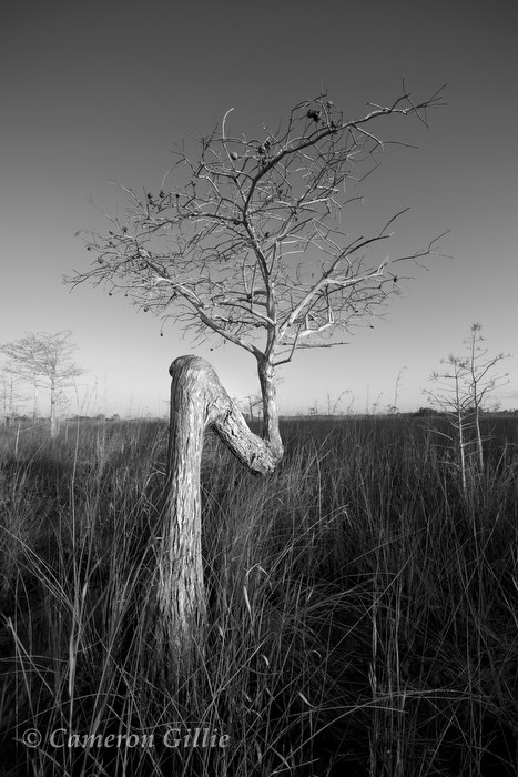
This dwarf cypress jumped out at me. I’ve seen trees grow like this a few other times in the Everglades and recently in Wisconsin. I’ll have to ask a ranger for an explanation.

The drive down

I  lived in South Florida for six years, so I know the annual January influx of the snowbirds well, but yesterday I unwittingly experienced the migration first hand on I-75. Like everyone else who comes to Florida in the winter I waited till after the holidays and started driving down in early January. There I was on Interstate midway down the peninsula in stop and go traffic at times. The rest stops had cars backed up onto the off-ramp waiting for a parking spot and I had to stand in lines to use the facilities. It was hard to believe I was in the middle of nowhere in a long traffic jams with other salt stained cars with licenses plates from New York, Ohio and Minnesota.

In winter months Florida bursts at the seams with people in search of warm sunny weather, packing restaurants and creating non stop traffic jams and using a lot of water. All during the dry winter season when very little rain falls to replenish the aquifers that provides this water.  South Florida’s water supply is where I’m sitting right now, the Everglades. That traffic I was in today really illustrates the wintertime demand put on the water of the Everglades.

Climate Change and Everglades National Park

A big reason for my passion for the Everglades is this place is literally a “canary in a coalmine” situation for climate change. If even the most modest global warming predictions come true, sea levels will rise and reshape this beautiful park. A large portion of the park and many places I will be photographing may disappear into the Gulf of Mexico.

The other night I was watching the anti global warming pundits on TV claiming this is all one big hoax being committed by the science community. It inspired me to write this letter to the editor that was published in today’s Wisconsin State Journal…

Wisconsin State Journal- December 23rd

My only comunication while on the wilderness waterway

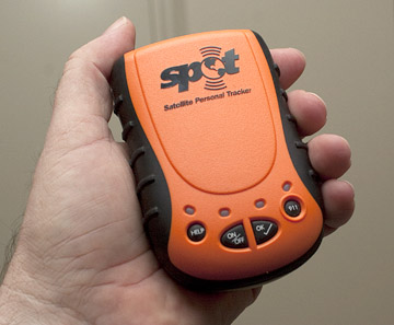
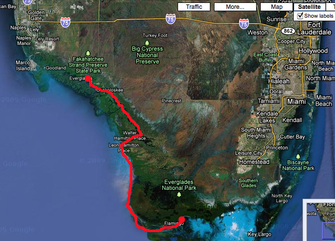
While out on the 11 day trip on the wilderness waterway, there is pretty much no civilization at all, including no cell signal. My only way of staying in touch will be what’s called a Spot Messenger. It’s a nifty little GPS that sends your coordinates via satellite displayed on Google maps to an email address with a pre-written “I’m okay” message. So Nazan will hear from me once a day when I make camp and know where I’m at. Nazan will post that map link on my facebook page so everyone can follow along with on my trip.

The messenger is a cool toy, but it also has a “911” button as well, so If I’m in trouble I can press the panic button and it sends my coordinates to the proper authorities to let them know I’m in need of rescue. In the Everglades I imagine that would be the Coast Guard or Park Service. So it also gives me a bit more piece of mind on a solo trip crossing the largest wilderness east of the Mississippi.

But the okay messages won’t always necessarily come through. It’s little hand held thing that is sending a message to space and back, so it’s not 100% reliable and has a poor signal if there is much tree cover where I’m at. There are also many other reasons it may not work, like I dropped it in the water, ran out of batteries or simply forgot to send the message that day. So I should stress that if there are no okay messages every day does not mean it’s time to panic. But it should be a fun way to follow along with where I’m at.

Click here for a test transmission I did in our yard in Madison…

The planning process for paddling the wilderness waterway

Water everywhere, but Ironically the biggest obstacle is water. Being the wilderness waterway is entirely brackish water, I need to carry all my fresh water with me- and fit it in a 27 inch wide 34 pound solo canoe. Along with everything else including, camping gear, cameras, tripod, and food. So I find myself debating bringing anything not completely essential; like a chair. But, then it is nice to sit down after a day of paddling?

Luckily Bill Blanton, the editor who coincidently first assigned me to canoe the wilderness waterway in 1997 at the Naples Daily News, is now a fishing guide in the Everglades. He has a super fast boat to cover long distances in a short amount of time. He’s offered to bring me a resupply of water at the halfway point on Highland Beach. My entire trip will require somewhere around 12 gallons of water, which doesn’t sound like much, but that weighs 100 pounds, not having to cary all of that at once makes life a lot easier.  So I can maybe afford the weight of a chair! Hooray for Bill!

It all comes down to weight, especially being I weigh over 200 pounds to begin with. So over the next month there will be lots of weighing stuff, packing it and unpacking it in the canoe sitting in the garage figuring out what comes and what stays at home. A very wise thing an experienced backpacker told me once. “It’s not figuring out what to bring, its figuring out what NOT to bring.”

The wilderness waterway is basically a maze of small mangrove islands with intertwining tidal rivers running through them. So there are countless routes you can take (and get lost in). I’m planning on spending the first 5 days or so on “the inside” through the maze of mangroves. Campsites are maintained by the park called Chickees, which are simply a 12×12 foot dock over the water. It’s kind of a cool experience to camp “on” the water, but as far as photography is concerned it is a bit limiting. So the second half of the trip I’m going on the outside along the Gulf of Mexico. On the coast you camp on the beaches of the outer islands. Highland Beach, a 2 mile long strip of sand is the halfway point where I will spend 2 nights and take a day off from paddling. This is when Bill will bring the water, I’m also going to see if Bill can bring a six pack of beer too! (In cans though, so I don’t have to carry out bottles) it will be warm beer by nightfall, but I’m sure it will be pretty tasty. Here’s a shot from highland beach…

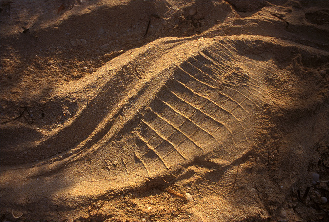
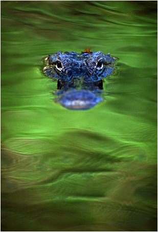
The second half of the trip I will round Cape Sable, the southernmost point of the mainland United States. Cape Sable a sweet place, 14 miles of beach that you have almost entirely to yourself. It is home to some of the last remaining endangered American crocodiles. Crocodiles, unlike alligators who live in fresh water, live on the coast in brackish and salt water and nest on wilderness beaches. There aren’t a whole lot of beaches left in Florida that aren’t lined with condos, therefore there aren’t many crocodiles left. The last time I camped at Cape Sable I got to watch a crocodile swimming around in the Gulf, which was a very cool experience. One spent the night sleeping about 100 feet down the beach from me, which I never saw, but I did discover the evidence the next morning. which made for one of my all time favorite photos…